|
Cache location: N 52° 20.400 E 005° 17.103 Since generations the family Koebonte, Braecklingde and Janszoon, all shipscrew from Vlefolande, went sailing together over the world seas. Once started in 1816 on the koggeschip (old style ship) “The Almearder” and later on other and newer ships, always carrying the name “Almearder”. Helmsman Boeke Janszoon used a sextant on the koggeschip “The Almaerder”, an important nautical instrument to calculate the position at sea. 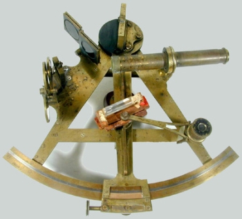
sextant Around 1730 the sextant was invented, a measuring instrument used to measure the angle of elevation of a celestial object above the horizon. Geographical latitude Lines of latitude appear straight and horizontal, but are actually circular with different radii. They are the horizontal lines shown running east-to-west on maps, north or south of the equator. The equator itself is a latitude. This equator divides the planet into a Northern Hemisphere and a Southern Hemisphere, and has a latitude of 0°. For stipulating the geographical breadth in the northern hemisphere one can measure the angle between Polaris and the horizon. Because Polaris stands nearly above the horizon (but infinitely far), the angle between Polaris and the horizon (it horizontal area on the spot), is equal to the latitude. In the Southern hemisphere one can take the "Southern Cross" for this angle provision, or one of the many other celestial objects mentioned in the celestial navigation almanac. 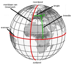 Geographical longitude The fictitious lines on the world globe, between the North- and South pole one calls the longitude lines (or meridian). Meridians do not run parallel to each other, the lines meet at the North- and South pole. A well-known meridian line is the "0-degree meridian of Greenwich" (the prime meridian), eastern of it one speaks of Easterlength and western of Westernlength. Stipulating the geographical length has long been a problem.The solution proved to be the invention of a chronometer (precise clockwork), with which the local time of "Greenwich" could be taken along the seatravels. The afternoon hour (12.00) in Greenwich was stipulated by the moment when the sun stood on its highest point. They took along that local Greenwich-time (established on highest point sun = 12.00 o'clock at noon) on their sea travels in western direction. Locally they examined how late (Greenwich-time) the sun stood there on its highest point. If that was 3 hours later than in Greenwich, they where 3 x 15 length degrees West of Greenwich (in 24 hours the earth twists 360 degrees, therefore 15 degrees per hour). 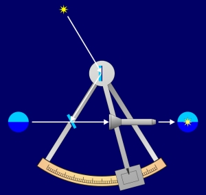
With the sextant it was stipulated when the sun stood on its highest point and than they good read the degree partitioning. Precise clockwork was very important. The English watch maker John Harrison invented a functional and precise chronometer (ships clock). After a test on a sea journey to the Caribbean, the clock of Harrison had a deviation of only 39 seconds. 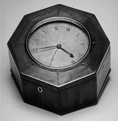
Harrison Chronometer Much success in finding the cache.
|