HOME
Uncertainty and likelihood of
geological and geotechnical property models of the sub-surface - hazard and risk
analyses
Uncertainty model
In engineering geology or
geotechnical work common practice is (or should be) to make an estimation of the
error (or likelihood) of properties in the subsurface and the influence of these errors on the
engineering application to be built in or on the sub-surface. The later is also denoted
as a hazard and risk analyses for an engineering structure due to uncertainty in
geotechnical properties in the sub-surface. Different methodologies, such as
"geotechnical base-line methods", probability studies, Monte Carlo simulations,
exist to be able to give a certain amount of quantification of possible errors
made in the design of an engineering structure due to uncertainty in sub-surface
properties. However, two very important main points are only very rudimentary or not
addressed in these analysis. To understand this it is necessary to go back to the basics of
engineering geology or geotechnical engineering.
|
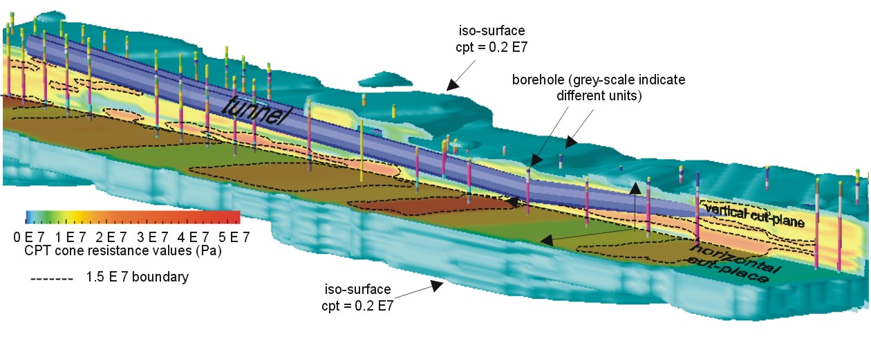
Fig
1. Example of
3D-GIS visualization of proposed tunnel alignment in a solid volume
model of distribution of CPT cone resistance values, with boreholes
showing geotechnical units and two cut-planes to show the distribution
of CPT values (Heinenoord Tunnel, Netherlands; after Ozmutlu, 2002)
|
It is normal to make a three-dimensional model of the geotechnical property
distribution of the sub-surface (fig.1). Such a model consists of a boundary model that
gives the boundaries between the different defined geotechnical units (note 1)
and a property model for the distribution of geotechnical properties in the
geotechnical units. In principle the model has to be three dimensional and be
able to represent changes in time of geotechnical properties (e.g. the model
should be four-dimensional with time as fourth dimension).
Statistical routines exist, in
extenso, to calculate the temporal-spatial distribution of properties in a unit.
Also the likelihood of the distribution, or better the error made by estimating
a property at a certain location in space, is well defined if appropriate
statistical routines are used. But inherit to the likelihood of properties is
the correctness of the boundaries the geotechnical units. This correctness depends on 1) the geology and 2) the variation in properties allowed
for each geotechnical unit.
Geology interpretation
The interpretation of the geology is
normally done by a geologist, engineering geologist, or a geotechnical engineer.
In the interpretation the geologist or engineer makes use of a priori existing
knowledge of the geological environments which he or she thinks to be present. The quality of this information which is
essential in the interpretation, can, in general, not be quantified at present.
If
the engineer is good there will be a good model, or a poor model will result if
the geologist is not so good. How "good" or how "poor"
nobody can quantify.
Establishment of geotechnical units
The establishment of geotechnical
units, as well the boundaries as the allowed variation of properties within
each unit, depends on engineering judgment. Generally, it will be based on a
balance between improved detail against higher
costs (see also below note1).
It is clear that no decent analyses
of hazard and risk can be made if these two interpretation errors cannot be
quantified. Any analysis up-to-date describe wonderfully all sorts of
uncertainties in measurable properties, but is totally lacking the main
parameters resulting from the interpretation. Lets make that clear with an
example.
Example: marine or fluvial
In the western part of the
Netherlands sedimentary layers have mostly a marine or a fluvial origin. Assume
that a foundation has to be made on a sand body in the sub-surface. Some
boreholes (or in the Netherlands Dutch Cone Penetration tests, CPT's) have been
made and show in all a sand layer to exist roughly at the required depth. Now
the interpretation starts. If the sand layer is of marine origin it can
reasonably safe be assumed that the layer is continuous, however, if the sand
layer is of fluvial origin it is in contrary likely to be a lens with a limited
lateral extension, and may or may
not be continuous between two boreholes or CPT's. An engineer who knows in which
formation the sand layer is situated (e.g. of marine or fluvial origin) will
likely make a correct interpretation, while, his colleague who does not know or
who makes the wrong assumption, produces a completely wrong interpretation with
all consequences for the foundation and the building resting on it.
Research at ITC
The problem of quantification of
interpretation errors and unknown likelihood of geological models and geotechnical units has been
subject of research already for many years in ITC's Section of Engineering
Geology. The research question originated with the use of two- and
three-dimensional GIS for sub-surface interpretation. It was not long after the
first use of GIS that the question came "what is the reliability of all
these
wonderful computer generated models". Nobody could give an answer except with "it
looks good, so it is probably good", which is clearly unsatisfactory! Therefore
years ago research has started to try to develop methodologies to solve this
type of problems.
Ongoing research:
Likelihood of geological and
geotechnical models of the sub-surface (work title). PhD research. Researcher:
Sicai Zhu, Supervisors: Hack, Turner & Hale
Homogeneity of units by Lidar (work title),
Researchers: Slob & Hack
Published research output:
Articles: See Publications
PhD research theses:
1997. Predicting subsurface conditions for geotechnical modelling / by B.
Orlic. - Delft : ITC, 1997. - 192 p. ; 25 cm. - PhD thesis Technical University Delft ; Summaries in Dutch and English. - ISBN 90-6164-140-3.
(ITC Publication ; 55) (ITC Dissertation ; 46). ABSTRACT, supervisor: Hack,
thesis availability:
ITC Library
M.Sc. research theses
Theses fully directed towards uncertainty
and likelihood
2001. Variability analysis of rock mass properties
using in-situ block size distribution / by Abera Abebo Hamore - Delft : ITC, 2001. - 109
p. ; 30 cm. - ITC-MSc thesis. ABSTRACT,
supervisor(s): Slob, thesis availability:
ITC Library
2000. Uncertainty in 3D subsurface geometry modeling
Comparison of expert versus alpha-complex modeling / by S. Staffhorst, MS Thesis, Delft University of Technology,
Delft (2000).
ABSTRACT, supervisor(s): Hack
& Turner
(Technical University Delft),
thesis availability: Technical
University Delft
1992. Reliability assessment of rock mass characteristics in GIS applications / by Luis Fernando Contreras
Bohorquez. - Delft : ITC, 1992. - 120 p. ; 30 cm. - ITC MSc-thesis. ABSTRACT,
supervisor(s): Hack,
thesis availability: ITC
Library
Theses related partial to certainty
and likelihood:
2000. Comparative settlement analysis by using 3D-GIS
and 2D-FEM approaches / by N.B. Yenigul, Delft : ITC, 2000. - 117 p. ; 30 cm. - ITC
MSc-thesis.
ABSTRACT,
supervisor(s): Ozmutlu
& Zigterman, thesis availability:
ITC Library
1998.
The
development of an Expert System for TBM application in soft soil / by
A.M.van Noort. ABSTRACT,
supervisor(s): Hack, M.T.J.H. Smits (Fugro Engineers,
Leidschendam, The Netherlands), &
C.N.Bremmer
(NITG, Delft, The Netherlands). thesis availability:
Technical University Delft
1997. A decission support system for shield tunneling;
for For bored tunnel projects in soft soils in the Netherlands. / by
ing. R.P. van der Putten. ABSTRACT,
supervisor(s): Hack &
M.T.J.H. Smits (Fugro Engineers, Leidschendam, The Netherlands).
thesis availability: Technical
University Delft
1996. GIS application in foundation coast zonation for an area in Sliedrecht The Netherlands Vol. II. appendix. / door Senaka
Welideniya. - Delft : ITC,
1996. - 125 p. ; 30 cm. - ITC MSc-thesis. ABSTRACT, supervisor(s): Hack,
thesis availability: ITC
Library
1995. 3D - GIS Modelling for
geotechnical purposes: Sliedrecht, Netherlands /by Panya Somboon-anek.
- Delft : ITC, 1995. - ?? p. ; 30 cm. - ITC MSc-thesis. ABSTRACT,
supervisor(s):
B. Orlic (NITG, Delft, The Netherlands) & Rengers,
thesis availability: ITC
Library
1990. The application of ILWIS in the estimation of safety of mine pillars / by B.
Orlic. - Delft : ITC, 1990. - 80 p. ; 30 cm. - ITC MSc-thesis. ABSTRACT,
supervisor(s):
Bekendam (Technical University Delft).
thesis availability: ITC
Library
|
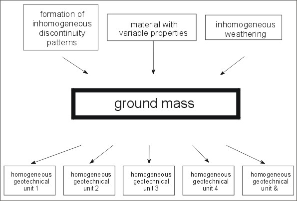
Fig. 1
. Mass components
(after Hack, 1998)
|
Theoretically, a proper description or geotechnical
calculation to determine the behavior of a soil or rock mass and engineering
structure in or on the soil or rock mass should include all properties in the
mass including all spatial variations of the properties. This would be
unrealistic and is not possible without disassembling the mass. Therefore, a
standard procedure is to divide a mass into homogeneous geotechnical units. A
geotechnical unit is, in theory, a part of the mass in which the mechanical
properties of the soil or intact rock material are uniform and the mechanical
properties of the discontinuities (including anisotropy of properties) within
each set of discontinuities are the same. The anisotropy of properties in a
geotechnical unit should be also uniform. This additional condition is not
always specified in the literature; however, in engineering it is an obvious
requirement because of the large influence of anisotropic features (e.g.
discontinuities, etc.) on engineering.
Fig.
1
shows a schematic visualization of a ground mass and its division in
geotechnical units. In practice, homogeneity is seldom found and material and
discontinuity properties vary within a selected range of values within the unit.
The allowable variation of the properties within one geotechnical unit depends
on: 1) the degree of variability of the properties within a mass, and 2) the
context in which the geotechnical unit is used.
A ground mass containing a large
variation of properties over a small distance necessarily results in
geotechnical units containing larger variations in properties. This is because
it is impossible to establish with sufficient accuracy all boundaries between
the various areas with different properties within the mass. The smaller the
allowed variability of the properties in a geotechnical unit the more accurate
the geotechnical calculations can be. Smaller variability of the properties of
the geotechnical units involves, however, collecting more data and is thus more
costly. The higher accuracy obtained for a calculation based on more data has,
therefore, to be balanced against the economic and environmental value of the
engineering structure to be built and the possible risks for the engineering
structure, environment, or human life. The variations allowed within a
geotechnical unit for the foundation of a highly sensitive engineering structure
(for example, a nuclear power station) will be smaller than for a geotechnical
unit in a calculation for the foundation of a standard house.
|
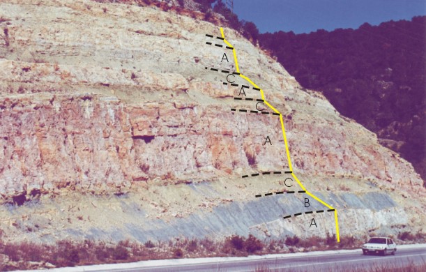
Fig.
2.
. Different
geotechnical units present in a single slope. Greenish and bluish gray
layers consist of calcareous shale and brownish, pinkish off-white
layers consist of dolomite and limestone.
|
No standard rules are available for the division of a mass into
geotechnical units and this transformation depends on experience and
‘engineering judgment’. However, features such as changes in lithology,
faults, shear zones, etc., are often the boundaries of a geotechnical unit. In Fig.
2 a slope is shown in which different geotechnical units are present. The
influence of the different geotechnical units on the form of the slope is
clearly visible through the changes in slope surface steepness.
HOME
Last update of this page:
14-Dec-07 14:47 webmaster