Being a professor brings with it some obligations. People expect you to know everything or at least to know more about anything than they do.
So I undertook the job of finding out how accurate the GPS12 is because that question comes up as soon as I have explained what the GPS is for.
Let's look a some waypoints. I made some screendumps where you can see square pixels (high zoom-level of the map) that span 2.5 m each. (400 pixels/km)
On the recent topografic map 1:25.000 you can find a Dutch 'GPS kernnet punt' named 319330 Steen RD Zuiddijk that is about 1 meter south of the bicycle road. I measured a position of 100823 / 456544 in meters. It is marked on the map with a triangle, the centre of it is the mark. I averaged the waypoint for 30 minutes. As you can see the position error is minimal: exactly in the centre of the symbol. But it looks like the point is in the middle of the road and that it is surely not. Months later I received the official position of this marker (I cannot give that you here because of copyrights) up to the centimeter. And now I know that I was at most 70 cm off in both directions. So let's not be to optimistic and say: 1 meter wrong.
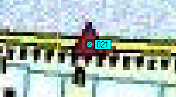
Here I measured the middle of the footbridge crossing the sluice. The building housing the pump is the black rectange where the text 'sluis1' is pasted over. The thin white lines are part of the 100 meter grid I placed on the maprepresentation. The sluicegates are west of the building and the bridge about half way between inlet and outlet. When I count the number of pixels east of the 104200 line there are 8. That gives 20 m or 104220 and I measured 104218. The same you can do for the northing position. Here the line is 455600 and I count one or two pixels down to the position what amounts to 2.5 to 5 m giving 455595 and the measured position is 455596. So the position looks totally OK to me again within 2 m.
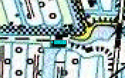
For a third experiment I use the position of cache 'Platland'. This cache is in the N-corner of the culvert connecting the road to the grazing field. The waypoint is indeed placed within a pixel (2.5 m !!) distance of the right position. Counting pixels north from the red horizontal line that gives the 458000 line I count 3 pixels what translates to 7.5 m. The position as measured with the normal amount of averaging is 092204/458007 so that gives 7 m. A remarkable coincidence!
There are a lot of tracks for me to choose from. First a favorite of mine: a part of the track to cache Platland. That day there where enough satellites in view, there are no obstacles around and nothing to cause multipath of the GPS signal. The only obstruction of the sky is my person sitting on the bicycle with the GPS12 on the handlebar.
The most northern track is the first. It is on a gravelroad and I kept to the right track. About 30 minutes later I went back the road in the other track. This track is always south of the first one and the distance between the tracks is about 2.5 m, being the axial width of the agricultural machines. As you can see: a perfect match. This shows that within a narrow timeframe and using nearly the same satellite configuration differences of 2 m are resolved. Should I make the same track but days later then I cannot count on exacty the same positions but is is to be expected that again both (the coming and the going) produced tracks will show this distance between them.
And now a track with much less ideal signal reception.
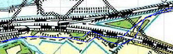
Look at the south track. I came along from left to right and the first part has some treecover. The railwayline is at least 8 m hight and there are trees all the way down to the path. So a big part of the sky is not seen. Also the satellite configuration was not so good and the possibility of multipath should be taken into consideration (electrical wiring of railway). Look at the points and not the blue line. The points are sometimes 5 m off from the path (striped line) but also sometimes right on top!
When I cross the railwayline through a tunnel, reception is lost and the GPS12 goes on thinking I am heading in the same direction with the same velocity. As soon as reception is reestablished a point is noted. That point is way off! But also the next point is wrong while the one after that is placed very well (on the path again).
The same happens with the return track: the first point after loss of reception is wrong and because of bad receiving conditions the error is propagated to the next points. I even seem to ride the railway!!!
This story has started in the spring of 2002. In the beginning of March 2002 I got a laptop with good batteries that allow me to make measurement series of 1 1/2 hour duration. With the method of postprocessing one should be able to get accurate positions within 1 meter.
Also I needed a way to get absolute positions of official measured points. That information is not for free. But asking the authorities for a single pointposition and explaining the 'why' to them resulted in a very positive respons. Further more I will need the postprocessing corrections and those are also commercialised. But for scientific purposes and research something can be arranged. And again, explaining my reasons for asking I got all the support I wanted.
In the spring of 2002 I had some preliminary results that were very encouraging. All through the summer I made measurements. Read here more about it!
In this case you can use the following trick: set your tracklogging to once a second. Most handheld GPS have a choice between 'automatic', 'time' and 'distance'. Then with some mathemagic you can find the centre of this cloud of (track-)points. There are many GPS programs that are able to group points and find the central position.
Moving around makes your position less accurate. Not because of movement itself but because the recieving conditions vary and are sometimes very bad. Position errors propagate to the next trackpoints especially under conditions of bad reception.
The best way to be sure of a position is: good view all around and average the waypoint. My experience is: during the first few minutes of averaging you see the position converging to stable numbers on the screen. I have never seen the numbers change anymore after 15 minutes of averaging.
The position you get is always (95 % probability) within 5 m of the real position.
![]()